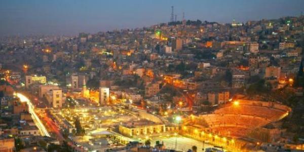


Madaba serves as the gateway to the King’s Highway which extends down to approximately 150 kilometres to Petra, representing the Kingdom’s premier touring corridor. Madaba is an important hub link for all types of tourism. Religious sites, leisure, trekking and walking through canyon trails, are all possible in this governorate.
The Umayyad sites in the region are Umm al-Walid Mosque, Umm Ar-Rasas, Qasr al-Mushatta, Qasr Zizia, Qasr al-Qastal (the earliest still existing Umayyad Mosque), and Qasr al-Hammam. Islamic sites include Abu Tharr al-Ghaffari, and Khan Az-Zabib Mosque.
For the Christian visitors, Madaba also offers tremendous appeal in the trio of the Baptism site, Mt. Nebo for Moses, and Mukawir for St. John the Baptist. This cluster contains Jordan’s part of the Biblical Holy Land and is rich in traces of the later Byzantine and Umayyad Christian era.
In general, the sites of these clusters cover an area within a 30-minute driving radius from Madaba core.
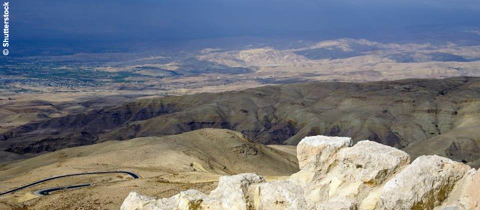
Visiting Madaba's surrounding region, it’s possible to discover Mount Nebo to the West, Wadi Mujib and Umm Ar-Rasas to the South, and Hisban to the North, and the other important neighbouring Holy Land sites such as the Dead Sea to the West and the Bethany Baptism Site to the North West. Extending from Bethany in the North to the villages of Dhiban and Umm Ar-Rasas in the South, this cluster covers a scenic and very historic area known over two thousand years ago as the Plain of Moab, (also called the Dead Sea Highlands).
The Madaba region has been the stage for great events that have influenced human history and religion. About 19 million years ago, the Earth heaved and gave birth to these dramatic landscapes: the rift valley, the lowest place on earth, the Dead Sea; and high above, the Biblical “Plains of Moab”. This unique natural formation has remained relatively unchanged since people first settled here more than five thousand years ago.
Ten minutes’ drive to the Northwest of Madaba, lies Mount Nebo, the final station in Moses historic flight from Egypt to the Holy Land. Here, from the same platform where the late Pope John Paul II stood in the year 2000, it can be admired the panoramic view of the Holy Land, spanning the Jordan Valley and the Dead Sea, just as Moses glimpsed it more than 3,000 years ago. Because of its association with Moses, Mount Nebo became a place of pilgrimage for the early Christians. A monastic foundation and a late 4th century chapel built to commemorate the death of Moses, alongside a standing 6th century church, remain.
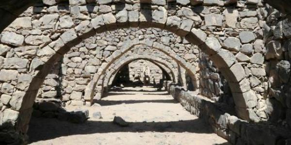
A half hour drive southeast of Madaba it’s Umm Ar-Rasas, a UNESCO World Heritage listed site. Umm Ar-Rasas, the ancient Kastron Mefaa, also one of the many important Islamic sites in this governorate, was mentioned in both the Old and New Testaments of the Bible. The rectangular walled city was abandoned after a mighty earthquake hit the region in 749. Although mostly in ruins, you can still see several restored buildings, including four churches and some beautiful stone arches. You can also enjoy the very large and perfectly preserved mosaic floors of the Saint Stephen’s Church complex, dating from the 8th century which have only recently been carefully excavated from beneath the sands of centuries. A few kilometres away, you can wonder at a 15-meter high stylite tower without a door or inner staircase. It was probably used by early Christian monks as a place of solitary meditation.
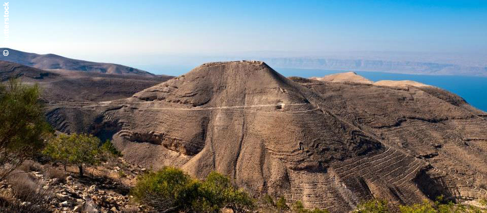
Mukawir, ancient Machaerus, is about 30 minutes’ drive southwest of Madaba on the Kings' Highway. Here, at his fortified hilltop palace, Herod Antipas imprisoned and beheaded John the Baptist, “after Salome’s fateful dance.” Mukawir was one of the designated pilgrimage sites for the year 2000. From the top of this mound, you can enjoy a breathtaking view of the Dead Sea, especially at sunset.
Sports-minded visitors have a number of options for active touring and sports across the Moab highlands, Dead Sea and Wadi Mujib areas. The Mujib Nature Reserve in the south offers both easy and difficult trails for nature and adventure enthusiasts. Since ancient times, the nearby thermal mineral springs, called "Hammamat Ma’in," have drawn people seeking the benefits of this natural wellness spa.
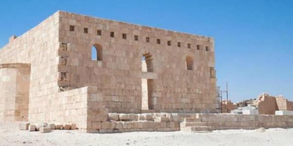
Archaeologists strongly believe that it was the Umayyad Caliph al-Walid II (743-744 AD) who commissioned the construction of this palace, according to the comparison of architectural and aesthetic applications as well as the materials used with other sites/monuments in the region. The Mushatta Palace was used to commemorate the Caliph’s authority. Being the largest of the Umayyad Palaces in Jordan, al-Mushatta lies 25 kilometres south of Amman and 20 kilometres east Madaba. A combination of limestone and brick is used in its construction. It consists mainly of the entrance hall, a mosque (with a mihrab still evident), an audience hall and some residential quarters. The living quarters comprise residential suits organized around central courtyards.
Archaeologists strongly believe that it was the Umayyad Caliph al-Walid II (743-744 AD) who commissioned the construction of this palace, according to the comparison of architectural and aesthetic applications as well as the materials used with other sites/monuments in the region. The Mushatta Palace was used to commemorate the Caliph’s authority. Being the largest of the Umayyad Palaces in Jordan, al-Mushatta lies 25 kilometres south of Amman and 20 kilometres east Madaba. A combination of limestone and brick is used in its construction. It consists mainly of the entrance hall, a mosque (with a mihrab still evident), an audience hall and some residential quarters. The living quarters comprise residential suits organized around central courtyards.
It is suggested by archaeologists that the building was never completed. Some of the palace sections are still at the foundation level, particularly near the southern limits of the palace. It is suspected that the palace incompletion was related to the political turbulence of that period, as the Abbasids took over the Umayyad rule and moved the capital to Baghdad.
Creswell, K. A. C. (1989), 'A Short Account of Early Muslim Architecture'. Revised and supplemented by James, W. Allan, Scholar Press, Scholar Press, p.201. Adopted from Grabar, O., The Formation of Islamic Art, New Haven,1973.
The Palace is divided into three sections, of which only the middle part was built with its northern half fully completed. The remaining two parts, the eastern and the western, were abandoned before completion. The middle part is the most prestigious of the palace, consisting of the throne room and corresponding structures. A triumphal arch leads to the middle part. It rises on four pillars, giving its central arch a span of over 6.5 m. Three rosettes decorated the upper part of the side arches. A 27 m long vaulted tripartite hall links the arches to the throne room. The throne room has a brick dome and is surrounded by four compounds for royal household and domestic use. Each compound comprises two barrel-vaulted suits lightened by two oculus windows, and shares a courtyard with another compound. This arrangement is based on a classical model that goes back to the 3rd century AD, and reflects a common plan followed in civilian Umayyad buildings seen in Syrian today. The rooms are reminiscent of Sassanid Iran, perhaps to the Caliph wives. The eastern part contained the mosque with the mihrab appearing on the southern wall. The western part contained the living quarters made of numerous rooms organized around courtyards dedicated for guards, dignitaries and royal cortege.
Al-Mushatta is considered a showcase of early Islamic stone work and carved plaster of floral, animal and geometric motifs. The façade of the southern exterior has a 1.20 m high richly decorated strip with mouldings of pairs of interlacing vine-stalks, forming a loop that includes a vine leaf and a bunch of grapes. Above this strip is a panel 2.85 high decorated with zigzag pattern, forming large triangles with rosettes placed in the centre of each appearing a combination of lotuses and pinecones. The rosettes are surrounded by carvings of vines, humans and animals (e.g. lion, parrot, and buffalo, griffin, oxen, as well as mythical creatures like a dog-bird and a human head lion). The Palace has a Byzantine and Sassanian influence in the brick work as well as the plan and design. In fact, it is believed that the craftsmen were brought from Persia and Egypt, due to the palace’s decorative elements that contained Persian and Sassanian mythical animals and Coptic iconography. Christian builders might have gotten involved in the palace construction as cross-shaped marks have been noted. The Palace’s wall was given to Kaiser Wilhelm by the Ottoman Sultan Abd al-Hamid just before First World War, and now kept in the Pergamon museum in Berlin.
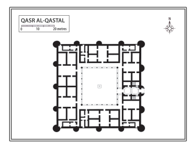
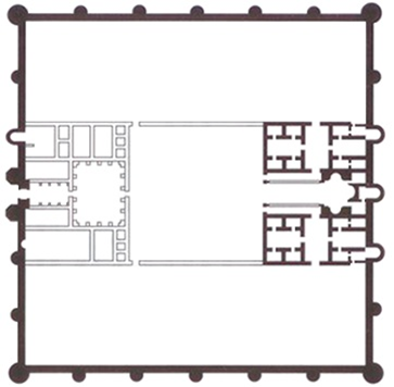
Located 20 kilometres east of Madaba and around 7 kilometres west of Qasr Mushatta, Qasr al-Qastal is a complex that encompasses a palace, a mosque, a water system, domestic quarters and a bath. Next to the palace lies a very early Islamic cemetery. A number of its inscribed tombstones date back to the Umayyad and Abbasid periods, and are currently on display at the Madaba Archaeological Museum. The palace is 70 x 70 m in size with a circular tower flanking each corner. Three semi-circular interval towers are located along all the walls, except for the eastern side which has the entrance and two towers only. The palace was built of ashlar-cut limestone, and fresco plaster covered walls from the inside. Mosaics also covered the walls and the floors of the palace. The palace courtyard (40 x 40 m) takes the centre of the complex, with six residential units organized around it surrounded by a portico. Each unit comprises four rooms organized around a rectangular courtyard. Another six units were built
Plan of Al Qastal Palace (see http://alextravelblog.com/jordans-desert-castles-qasr-al-qastal.html , after P. Cartier, 1984)
on the second floor reached by twine staircases. A water harvest system was put in place, channelling water from the roof down to cisterns using ceramic pipes. Lined with three layers of plaster, the palace’s cisterns are originally caves naturally occurring in a layer of limestone on which the qasr was built. There are around 70 cisterns around the palace, a large one lies under the palace’s central courtyard that has at least two entrances, one of which was decorated. The palace also has three large reservoirs (10,000 m2 in total). A system of channels links these cisterns to a spring on top of the hill. One kilometre to the east of the palace lies a 400 meters long and 4 meters thick Umayyad dam with a capacity to hold 2 million cubic meters. Traces of an ancient road from the Roman/Byzantine period have also been identified about a kilometre south-west of Qastal. There is also a mosque in the complex mosque with a minaret believed to be so far the oldest purposely built minaret in the world. The mosque’s mihrab was originally rectangular and later converted to the typical semi-circular shape. It is reached by a spiral stair. Marble columns and carved capitals flanked the mihrab at one point.
Like Qasr al-Hallabat, al-Qastal has a bath complex nearby, which was richly decorated with frescos, mosaics, marble tiled floors and carvings that depicted geometric, floral and animal motifs similar to those of al-Hallabat. The plan of the bath complex is similar to Qusayr Amra.
Scholars are still debating with regards to the date of the palace. Historical sources and certain stylistic features suggest 744 AD as the date of the palace completion. When al-Walid II visited the area in 743-4 AD, the palace was in existence. The layout of the palace (living quarters organized around courtyards) is very similar to other Umayyad palaces of this period, such as Qasr Kharraneh or Harraneh. The palace is dated to the reign of Yazid II ibn Abd al-Malik (720-740 AD) based on a reference to a palace in a contemporary poem to Yazid written by Kuthayyir ibn Abd al-Rahman ‘Azza (644-723 AD). Moreover, the construction of the palace is very similar to others constructed under Yazid’s patronage, such as Qasr al-Muwaqqar and the Umayyad Palace on the Amman Citadel. It is worth noting, however, that the construction might have begun before the reign of Yazid II. The palace was converted into domestic quarters during the Ayyubid/Mamluk period (12th -16th century AD).
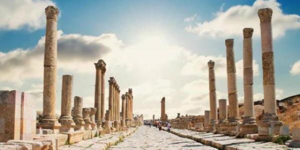
The ruins are 15 km southeast of Madaba. They cover the length of a small hill (about 40 m). The site has been occupied since the Bronze Age, archaeological explorations have focused on the Umayyad period, specifically on the eastern Qasr and the mosque. The ruins consists of ruins of a mosque, an Eastern Qasr, a central Qasr, a western Qasr, and two Roman temples. The complex of three palaces at Umm al Walid shows an urban pattern of settlement which consists of a unifying enclosure and a common court. The most excavated feature is the Eastern Umayyad Qasr. The mosque and al Qasr were built during the same period while they share the same building materials and same architectural motives. The Umayyad mosque located to the southeast of Madaba 15 km. is dated to the period 712-737 AD.
The Qasr is a square enclosure, measuring 70 m on each side. It has round buttresses at each of its corners and three-half round ones on the sides in between, except on the east side, which has only two. The walls built of local limestone and also include some embossed blocks apparently taken from earlier buildings (www.alextravelblog.co). The Qasr interior consists of 5 bayts arranged around a court yard, each bayt has 4-5 rooms. Some of the rooms were plastered, painted and decorated with stucco. A preserved example can be seen at Madaba archeological museum, in addition to ceramics and bronze vessels of the Umayyad period and a millstone from basalt.
The mosque located about 60m to the east of the al Qasr. Actually, there were two mosques, where the second was an enlargement of the first. The mosque is of a rectangular shape (11.67x12.67m2), with a mihrab, two entrances from the north and east sides, and with remains of a minaret alongside the end of the east wall. The interior of the mosque, shows two phases of construction. It is divided into nearly three equal parts by two arcades’ of three arches.
Khan el Zabib was one of the hijazi rail road stations, located near Qatrana, 35 km to the south the capital Amman . The caravanserai is 18 km south- east of Khirbet ez-Zona and 5 km east of the Desert Highway, and is well known as plainly Islamic. The materials and structures were the remains of a small late Roman town. Although now damaged, just beyond the north- east corner of Islamic caravanserai, the remains of a large rectangular structure may still be seen. It is dated to (712-37) AD .The fort or caravanserai function is unknown. Further doubt has now been cast that, as at Umm el-Walid, all of these structures are Umayyad. Khan al Zabib Mosque is with a rectangular shape (11.20x10.38m2) and has two entrances from the north and east sides, with a recess at the southern wall. Qasr al Hammam is an Ancient Ruin located near Al `Amiriyah, and 7.5 km from Khan el Zabib.